Our walking map
We have prepared a PDF map that includes all the walks in the area.
Discover our walks and GPX files hereunder

We have prepared a PDF map that includes all the walks in the area.
Discover our walks and GPX files hereunder
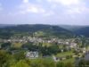
Discovering the magnificent view over the village of Poupehan
2,5 km • 3km • Difficulty 1/3
Know more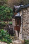
Enjoy refreshing wooded nature along the Moulin stream
5 km • 5 km • Difficulty 1/3
Know more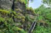
A steep path and a vast view of the surroundings. It is an adventurous hike.
9,5 km • Difficulty 3/3
Know more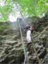
Beautiful sporty walk crossing the village of Poupehan
9 km • Difficulty 3/3
Know more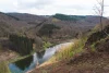
Wooded hill dominated by the viewpoint “the rock of the hawks”, Germowé and the site of Merleux-han.
8,5 km • Difficulty 2/3
Know more
Easy, picturesque and quiet walk. Barbecue area near the magnificent viewpoint of the Ecaillère.
5 km • Difficulty 1/3
Know more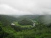
This site is one of the best known in the Belgian Ardennes and the Semois valley. Beautiful walk along the Giant’s tomb.
6 Km • Difficulty 1/3
Know more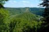
The tranquility of the banks of the Semois, the abbey of Cordemois and the opportunity to discover the Giant’s Tomb from another angle
7 km • Difficulty 2/3
Know more
From this legendary rock, admire the Semois which flows 70 meters below. Continue the walk along a small stream.
5 km • Difficulty 1/3
Know more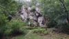
La Roche des Fées is a rocky ridge which was Christianized by a post to the Virgin Mary, not far from a legendary natural cavity.
2 km • Difficulty 1/3
Know more
Walk along the old tram route to France. The Bouillon/Corbion section opened in 1907.
5 Km • Difficulty 1/3
Know more
Historical walk where hovers the memory of the poet Paul Verlaine who lived at the “Maison des couleuvres” in 1885.
7 km • Difficulty 2/3
Know more